
Rolling Out a Car Free Path to the Beach

Rolling Out a Car Free Path to the Beach
By Benjamin Barnett

Slow Streets Golden Gate Park Opening Day

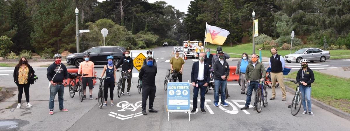
Last week, the Golden Gate Park Slow Streets Expansion opened to the public. People walking, biking, running and skating can now enjoy a nearly car-free route from the Panhandle all to the way to Ocean Beach.

Connecting the City 

Golden Gate Park Slow Streets are a collaboration between the SFMTA and the Recreation and Park Department. These new Slow Streets provide the last link in a route prioritized for people on bikes stretching from the Ferry Building to the ocean by connecting to the network of bikeways, Slow Streets, and streets previously closed during the health emergency. Starting from the Ferry Building you may now head down a Car-Free Market Street, then up the hill on the Page Slow Street connecting you to Golden Gate Park's newly expanded network.  

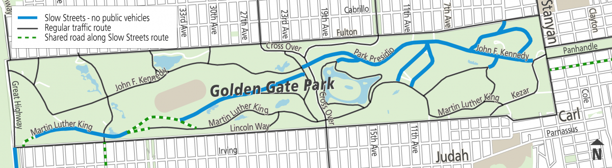
Golden Gate Park Slow Streets will begin at Stanyan Street and John F. Kennedy Drive East on the park’s eastern edge and connect with the stretch of JFK from Kezar Drive to Transverse Drive. The route then continues onto Overlook Drive, then Middle Drive and  Martin Luther King Jr. Drive to Ocean Beach, where it connects with The Great Highway. The Great Highway has also been closed due to the pandemic, and this connection creates a continuous, family-friendly path from the Panhandle to the San Francisco Zoo. 

Map of Golden Gate Park Slow Streets program

Not Entirely Car-Free 

To keep nearby traffic moving and maintain access for those that need to access the park in a car, a few areas are not entirely car-free: 

  • A 200-foot portion of the route on Transverse Drive, between JFK Drive and Overlook Drive 
  • An approximately half-mile portion of the Metson/Middle Drive/MLK Drive loop near the south end of the Polo Field 
  • The intersection at MLK Drive and Chain of Lakes Drive/41st Avenue 
  • A 500-foot stretch of MLK Drive near Lincoln Way 

In addition, authorized vehicles intended for park maintenance and ranger patrols will use the roads along the route when necessary. Motorists can still drive through the park from north to south using Transverse Drive, Chain of Lakes Drive, and 25th Ave/Crossover Drive/19th Ave/Park Presidio, as usual. 

New Traffic Flows 

Drivers will be rerouted from some east and westbound roads during Golden Gate Park Slow Streets, including: 

  • The west portion of MLK Drive west of Sunset Boulevard, specifically from the Middle Drive/MLK loop to Lincoln Way, is closed to regular traffic. This includes Bernice Rodgers Way, between MLK Drive and JFK Drive. 
  • Overlook Drive and Middle Drive, between Transverse Drive and the Metson/Middle Drive/MLK loop, will be closed to traffic. However, Middle Drive between Transverse and Overlook will remain open and available for street parking. 
  • JFK Drive, between Kezar Drive and Transverse Drive, will remain closed to traffic. This portion of the road had previously been closed during the City’s initial COVID-19 response. 

Golden Gate Park Slow Streets and the SFMTA Slow Streets initiative have the common goal of making San Francisco more welcoming and accessible for people who want to travel on foot, bicycle, wheelchair, scooter, skateboard or other forms of micromobility. Slow Streets are critical infrastructure that attracts users of the full array of neighborhood demographics—including children, older adults, people with disabilities and people of color. 

More information on Golden Gate Park including driving directions to your favorite spots, attractions or museums can be found here. 


Published September 25, 2020 at 04:35AM
https://ift.tt/3408X3c

Comments

Popular posts from this blog

150 Years Ago Today – The Cable Car is Born

150 Years Ago Today – The Cable Car is Born By Kelley Trahan August 2, 2023, marks the 150th anniversary of the world’s first successful cable railway, born right here in San Francisco. To celebrate the occasion, we bring you the story of Andrew Hallidie and the very first cable car company, the Clay Street Hill Railroad.  Andrew Hallidie (1834-1900) was a pioneering inventor and entrepreneur who changed urban transportation. In 1852, at the age of 18, Hallidie emigrated with his father from the United Kingdom to San Francisco during the California Gold Rush. His father, an engineer and inventor, had a wire rope patent that played a crucial role in his son's future success.   Portrait of Andrew Smith Hallidie in 1890. Inspired by his father's wire rope business, Hallidie developed a steel cable mineral mine hauling system in 1857. About a decade later, he designed a wire rope aerial tramway for transporting materials over mountainous terrain. Then, after a stint in bridg...

Shared Spaces are Here to Stay. Permit Renewals are Due January 15, 2023.

Shared Spaces are Here to Stay. Permit Renewals are Due January 15, 2023. By Anne Yalon Shared Spaces, amongst many other benefits, allows our residents and families to enjoy safe and social outdoor dining. Seen here are the the owners of Tio Chilo’s Grill and their children in the restaurant’s parklet on 24th Street in the Mission.  San Francisco’s popular Shared Spaces program allows merchants, restaurants and arts and culture organizations to use the curbside, sidewalk and other public spaces to conduct local business activities and stay afloat. What emerged as an economic lifeline during the pandemic is making San Francisco’s streets more energized, engaged and activated. Many of the Shared Spaces parklets have become central gathering places for the local community. “ Our parklet makes me feel like when I go to Mexico, where outdoor seating is everywhere. People end up joining their friends in our parklet. It is a space for our customers and our community," said Liz V...

Tenderloin Streets Transform During COVID-19

Tenderloin Streets Transform During COVID-19 By Kimberly Leung COVID-19 has disproportionately impacted people who live and work in the Tenderloin. As a result, the SFMTA has been working closely with District 6 Supervisor Matt Haney’s office, other city departments, the Tenderloin Traffic Safety Task Force and community members to address the public health issues and unique challenges in the neighborhood through innovative interventions.    The Tenderloin is home to many of our most vulnerable communities including historically marginalized groups such as people with disabilities, residents of SROs and supportive housing and limited-English proficient communities. With every single street in the Tenderloin on the city’s High Injury Network -- the 13 percent of San Francisco streets that account for 75 percent of severe traffic injury collision and fatalities -- thi...