
Improved Muni Transit Information

Improved Muni Transit Information
By Kharima Mohamed

As part of the larger effort to provide improved transit information to Muni riders, we have significantly improved the SFMTA.com stop webpages with a focus on improved accessibility. 

Each of the over six thousand stops throughout the Muni Service Network has a unique webpage that displays multiple features. These improved features on the stop webpage help to improve the customer experience for riders to easily get all the information they need to get where they need to be.  

Features include: 

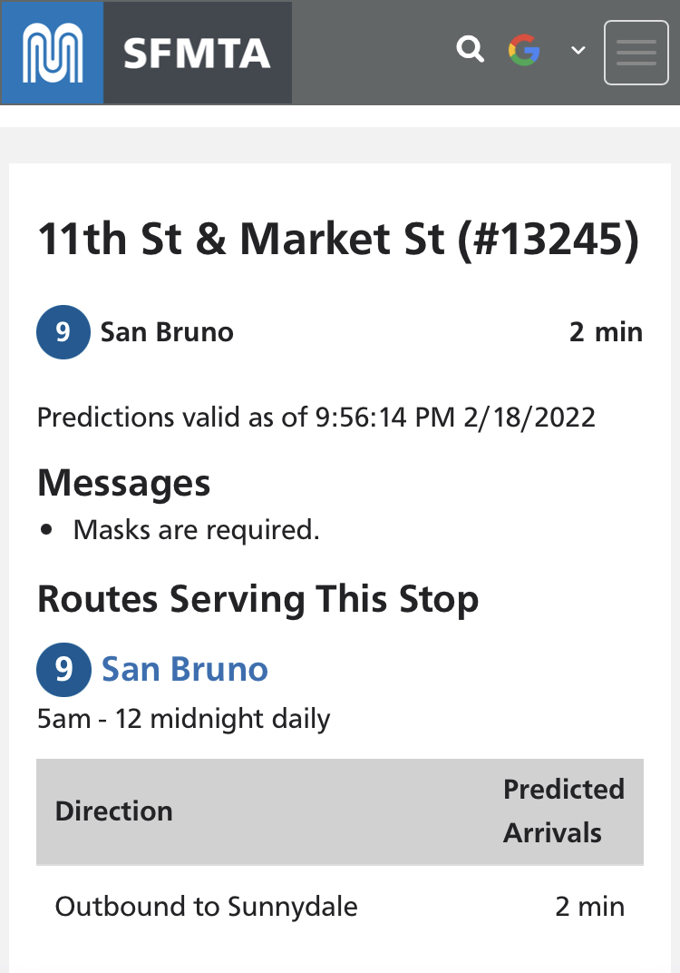
  • A mobile-first designed web app view for succinct on-the-go real-time vehicle predictions at the top of the page. 

  • Detailed route information served at each location. 

  • Alerts specific to both that specific stop and all of the routes served. 

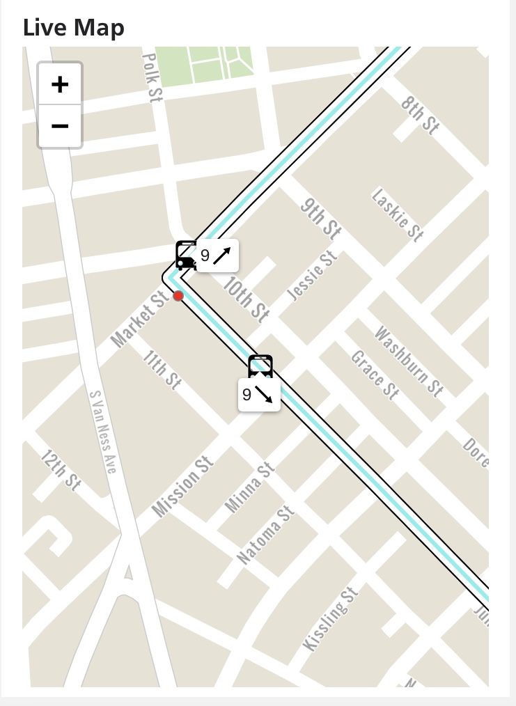
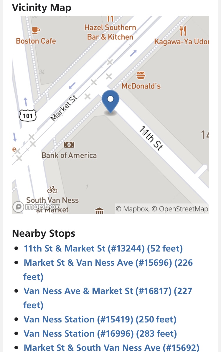
  • A real-time vehicle-tracking map and a vicinity map for each stop. 

  • Nearby stops to provide stop options if an alternative is needed. 

To visit the new stop page of your choice, simply use its five digit stop ID. You can find the five digit stop ID at the top of the transit shelter. For example, the stop ID at 11th St and Market is 13425, the short URL is SFMTA.com/13425

Example image of a stop page using the transit shelter's five digit stop ID

Included in this release are enhanced accessibility features that allow screen readers to not only read the details of the stop’s service, but also display when a vehicle approaches to ensure that nobody misses their ride or gets on the wrong vehicle. 

Live map image showing the real time approach of a vehicle's arrival to ensure that nobody misses their ride or gets on the wrong vehicle.

Part of this update is an all-purpose “Find a Stop” page that supports geolocation, lookup stops or map interface to find any stop throughout the Muni Service Network. With a location services enabled on a customer’s smartphone this webpage returns to the nearest stops. The webpage also includes a lookup for address, intersection, and places of interest as well as a map interface for riders that do not wish to use geolocation. All the features on the stop webpage presents riders with multiple options to choose from to plan their Muni ride and continue their trip journey. 

Image showing nearby stops using geolocation services.

These enhancements are part of the Next Generation Customer Information System Project. Future improvements will soon include an improved multimodal trip planner, more accurate predictions and enhanced accessibility information for each stop that will enable improved accessible trip planning. 

As AT&T’s 3G decommissioning impacts NextMuni electronic displays*, the SFMTA.com stop webpages and third party transit information applications are easy-to-use options to get vehicle predictions and other much needed transit information so that you can plan your trip efficiently. *We anticipate a gradual wind down of the AT&T 3G service over the next few weeks. Our NextBus signs are currently operational, but this will likely change in phases.


Published February 26, 2022 at 03:21AM
https://ift.tt/TnaQMxg

Comments

Popular posts from this blog

150 Years Ago Today – The Cable Car is Born

150 Years Ago Today – The Cable Car is Born By Kelley Trahan August 2, 2023, marks the 150th anniversary of the world’s first successful cable railway, born right here in San Francisco. To celebrate the occasion, we bring you the story of Andrew Hallidie and the very first cable car company, the Clay Street Hill Railroad.  Andrew Hallidie (1834-1900) was a pioneering inventor and entrepreneur who changed urban transportation. In 1852, at the age of 18, Hallidie emigrated with his father from the United Kingdom to San Francisco during the California Gold Rush. His father, an engineer and inventor, had a wire rope patent that played a crucial role in his son's future success.   Portrait of Andrew Smith Hallidie in 1890. Inspired by his father's wire rope business, Hallidie developed a steel cable mineral mine hauling system in 1857. About a decade later, he designed a wire rope aerial tramway for transporting materials over mountainous terrain. Then, after a stint in bridg...

Shared Spaces are Here to Stay. Permit Renewals are Due January 15, 2023.

Shared Spaces are Here to Stay. Permit Renewals are Due January 15, 2023. By Anne Yalon Shared Spaces, amongst many other benefits, allows our residents and families to enjoy safe and social outdoor dining. Seen here are the the owners of Tio Chilo’s Grill and their children in the restaurant’s parklet on 24th Street in the Mission.  San Francisco’s popular Shared Spaces program allows merchants, restaurants and arts and culture organizations to use the curbside, sidewalk and other public spaces to conduct local business activities and stay afloat. What emerged as an economic lifeline during the pandemic is making San Francisco’s streets more energized, engaged and activated. Many of the Shared Spaces parklets have become central gathering places for the local community. “ Our parklet makes me feel like when I go to Mexico, where outdoor seating is everywhere. People end up joining their friends in our parklet. It is a space for our customers and our community," said Liz V...

Tenderloin Streets Transform During COVID-19

Tenderloin Streets Transform During COVID-19 By Kimberly Leung COVID-19 has disproportionately impacted people who live and work in the Tenderloin. As a result, the SFMTA has been working closely with District 6 Supervisor Matt Haney’s office, other city departments, the Tenderloin Traffic Safety Task Force and community members to address the public health issues and unique challenges in the neighborhood through innovative interventions.    The Tenderloin is home to many of our most vulnerable communities including historically marginalized groups such as people with disabilities, residents of SROs and supportive housing and limited-English proficient communities. With every single street in the Tenderloin on the city’s High Injury Network -- the 13 percent of San Francisco streets that account for 75 percent of severe traffic injury collision and fatalities -- thi...