
How Muni is Tackling the 10 Worst Delay Hot Spots Across SF

How Muni is Tackling the 10 Worst Delay Hot Spots Across SF
By Cassie Halls

The SFMTA has had its fair share of ribbon-cutting ceremonies over the last two years. These celebrations draw attention to some of our biggest projects. Also attention-worthy are some of the more incremental efforts happening at the agency.

One such effort led by the Muni Forward team is the Transit Delay Hot Spots Program, launched in February 2020. Muni Forward is known for corridor projects such as the L Taraval Improvement Project, 16th Street Improvement Project, and M Oceanview Transit and Safety Project. These efforts are increasing the already sizeable 80 miles of transit reliability upgrades since 2014. There are also other ways we’re working to slash travel times and improve reliability across the Muni network.

The Transit Delay Hot Spots Program aims to tackle the 10 worst “delay hot spots” each year, where buses crawl between stops at four miles an hour or less. We’re looking closely at the causes of delay at these hot spots, whether it’s a lengthy traffic signal, clogged curb or difficult turn. And results have been promising so far – with travel time savings of up to 50%.

We identified the slowest segments of the Muni network to improve travel time, whether on the highest ridership routes or less ridden but essential connector routes. This also helps us to support the Muni Service Equity Strategy. The Muni Service Equity Strategy aims to make measurable improvements to safety, connectivity to key destinations, reliability, frequency and crowding.

The hot spots fall on routes such as the 44 O’Shaughnessy, 8AX/BX Bayshore Express and 24 Divisadero. So far, we’ve noticed some patterns of what causes the most delay. Common causes of Muni delays include very close stop spacing (where stops are on both sides of the same intersection), tricky turns, traffic and curb space issues. We address these delays with a toolkit of priority treatments.

Map of Current Transit Delay Hot Spot locations . Hotspot locations: 19 Polk from Larkin Street/O’Farrell Street to Geary Street/Larkin Street, 27 Bryant from Cyril Magnin Street/5th Street/Market Street to 5th Street/Mission Street, 8 AX/BX Bayshore Express from Kearny Street/Sutter Street to Kearny Street/Bush Street, 24 Divisidero at Courtland Avenue and 30th Street/Mission Street, 44 O’Shaughnessy at Silver Avenue/San Bruno Avenue to Silver Avenue/Bayshore Boulevard, 37 Corbett at Church Street/Market Street to 14th Street/Church Street, 44 O’Shaughnessy at Woodside Avenue/Portola Drive to O’Shaughnessy Boulevard/Portola Drive, and the 54 Felton at W3rd Street/Van Dyke Avenue/Lane Street to Williams Avenue/3rd Street.

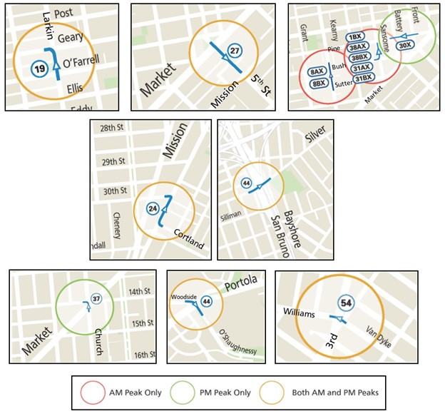
Maps of Current Transit Delay Hot Spot locations

The preliminary results of the program have been promising:

  • 54 Felton: Removing a nearside stop shortened travel times by 50%.
  • 8AX/8BX Bayshore Express: The NoMa/SoMa Signal Retiming Project cut pre-pandemic travel time by 20-25 seconds or around 22% and travel times have improved further with less congestion downtown.
  • 27 Bryant: The line was rerouted in SoMa to take advantage of transit lanes on 7th and 8th streets that were installed through the Temporary Emergency Transit Lanes program.   

You can read more about each of the hot spots on the Transit Delay Hot Spots program page. We will continue to track performance and community feedback and will make changes if needed.

We will be making improvements at three more hot spots over the next few months (two locations along the 44 O’Shaughnessy and one location on the 19 Polk). Each year, we will run the numbers on the 10 worst hot spots, install improvements and measure results. Stay tuned for more updates on our current hotspot program and our 2023 hotspot locations!


Published October 12, 2022 at 01:44AM
https://ift.tt/zwRPoDF

Comments

Popular posts from this blog

150 Years Ago Today – The Cable Car is Born

150 Years Ago Today – The Cable Car is Born By Kelley Trahan August 2, 2023, marks the 150th anniversary of the world’s first successful cable railway, born right here in San Francisco. To celebrate the occasion, we bring you the story of Andrew Hallidie and the very first cable car company, the Clay Street Hill Railroad.  Andrew Hallidie (1834-1900) was a pioneering inventor and entrepreneur who changed urban transportation. In 1852, at the age of 18, Hallidie emigrated with his father from the United Kingdom to San Francisco during the California Gold Rush. His father, an engineer and inventor, had a wire rope patent that played a crucial role in his son's future success.   Portrait of Andrew Smith Hallidie in 1890. Inspired by his father's wire rope business, Hallidie developed a steel cable mineral mine hauling system in 1857. About a decade later, he designed a wire rope aerial tramway for transporting materials over mountainous terrain. Then, after a stint in bridg...

Shared Spaces are Here to Stay. Permit Renewals are Due January 15, 2023.

Shared Spaces are Here to Stay. Permit Renewals are Due January 15, 2023. By Anne Yalon Shared Spaces, amongst many other benefits, allows our residents and families to enjoy safe and social outdoor dining. Seen here are the the owners of Tio Chilo’s Grill and their children in the restaurant’s parklet on 24th Street in the Mission.  San Francisco’s popular Shared Spaces program allows merchants, restaurants and arts and culture organizations to use the curbside, sidewalk and other public spaces to conduct local business activities and stay afloat. What emerged as an economic lifeline during the pandemic is making San Francisco’s streets more energized, engaged and activated. Many of the Shared Spaces parklets have become central gathering places for the local community. “ Our parklet makes me feel like when I go to Mexico, where outdoor seating is everywhere. People end up joining their friends in our parklet. It is a space for our customers and our community," said Liz V...

Tenderloin Streets Transform During COVID-19

Tenderloin Streets Transform During COVID-19 By Kimberly Leung COVID-19 has disproportionately impacted people who live and work in the Tenderloin. As a result, the SFMTA has been working closely with District 6 Supervisor Matt Haney’s office, other city departments, the Tenderloin Traffic Safety Task Force and community members to address the public health issues and unique challenges in the neighborhood through innovative interventions.    The Tenderloin is home to many of our most vulnerable communities including historically marginalized groups such as people with disabilities, residents of SROs and supportive housing and limited-English proficient communities. With every single street in the Tenderloin on the city’s High Injury Network -- the 13 percent of San Francisco streets that account for 75 percent of severe traffic injury collision and fatalities -- thi...