
Five Years of Data Show: Our Street Safety Projects are Making a Difference

Five Years of Data Show: Our Street Safety Projects are Making a Difference
By Julia Malmo

Ever wonder about the effectiveness of projects after they go into the ground? Us, too!  

That’s why, in 2017, we launched the Safe Streets Evaluation Program to help project teams understand whether a transportation safety project’s design is effective, and where there might be opportunities to adjust the design if not. Project evaluation data can also be combined across projects to help the SFMTA track the effectiveness of a certain type of safety improvement, which can in turn streamline the design of future projects. The Safe Streets Evaluation Program helps us work towards achieving Vision Zero, an initiative to prioritize street safety and eliminate traffic deaths in San Francisco.  

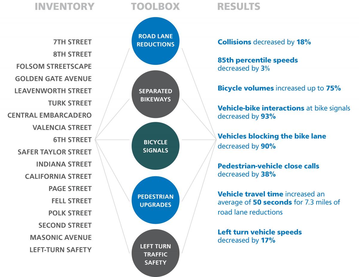
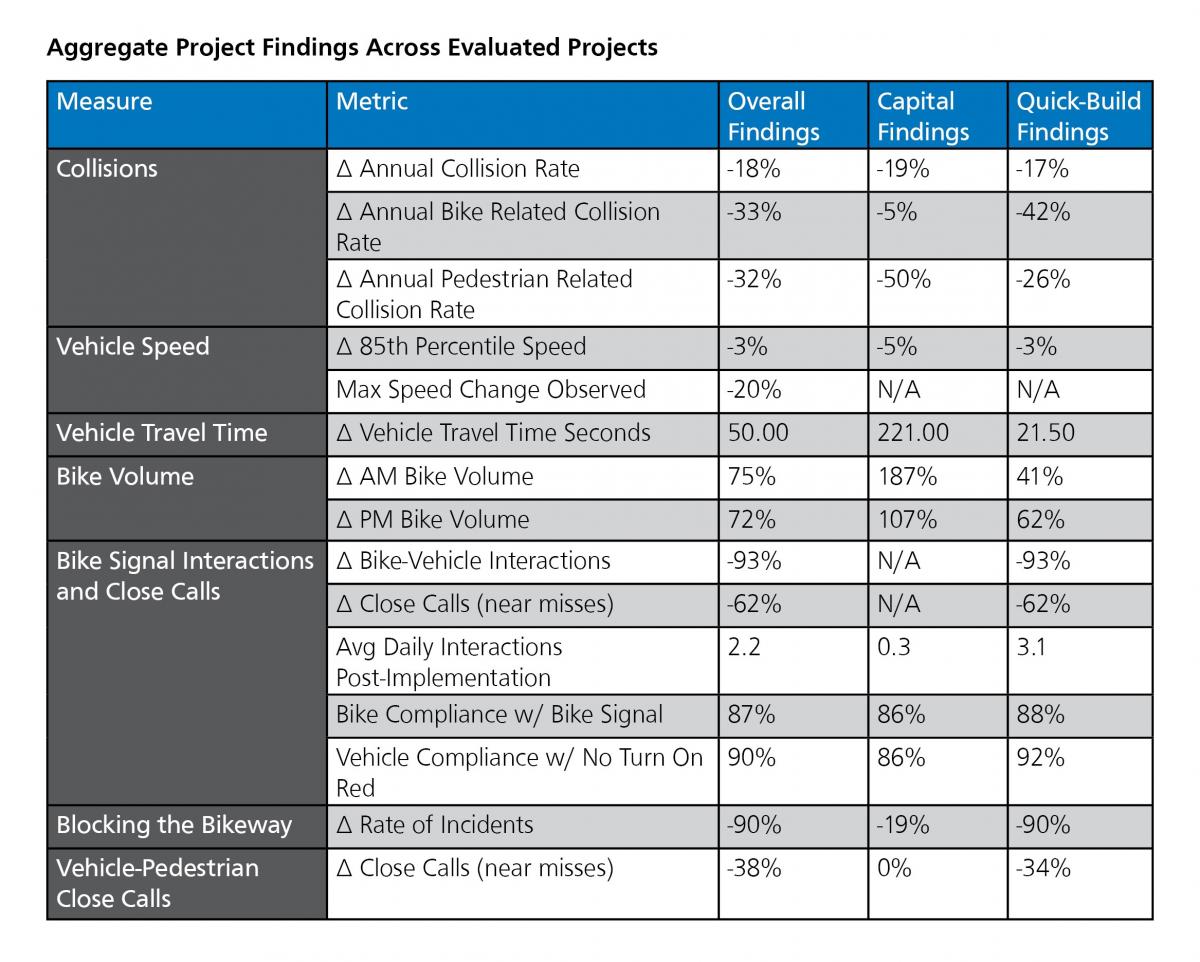
This week, we’re looking back on five years of data gathered through our Safe Streets Evaluation Program with the “2022 Safe Streets Evaluation Summary,” an interactive website summarizing the results of 18 bicycle, pedestrian and traffic safety projects implemented since 2017. 

Each of the 18 projects evaluated in the summary report added significant safety upgrades to the streets. Some introduced vehicle travel lane removals (road diets), separated bikeways, separated bike signals, or left-turn traffic calming devices. Others brought general improvements for pedestrians at intersections including pedestrian signal improvements, daylighting (red zones at intersections) and upgraded crosswalks. For every project, the SFMTA drew on a wide range of data—from project-specific observations, to police reports, to speed data—to create a comprehensive view into its’ effectiveness. 

An infographic displaying the project names, key design element, and results. In the lefthand column, under “Inventory” the following projects are listed: 7th Street, 8th Street, Folsom Streetscape, Golden Gate Avenue, Leavenworth Street, Turk Street, Central Embarcadero, Valencia Street, 6th Street, Safer Taylor Street, Indiana Street, California Street, Page Street, Fell Street, Polk Street, Second Street, Masonic Avenue, Left-Turn Safety. In the center column, under “toolbox,” the following elements are listed: Road lane reductions, separated bikeways, bike signals, pedestrian upgrades, left-turn traffic safety. In the righthand column, under “results”, the following findings are listed: Collisions decreased by 18%; 85th percentile speeds decreased by 3%; bicycle volumes increased up to 75%; vehicle-bike interactions at signals decreased by 93%; vehicles blocking the bike lane decreased by 90%; pedestrian-vehicle close calls decreased by 38%; vehicle travel time increased an average of 50 seconds for 7.3 miles of road lane reductions; left turn vehicle speeds decreased by 17%

The evaluation report indicates that the SFMTA’s safety tools are working together to create safer environments for all modes of transportation on city streets. 

You can dig into the whole set of outcomes on the website, but here are some highlights:  

  • Within the projects evaluated, annual collision rates decreased by 18%  

  • Bicycle-related collision rates decreased by 33% and pedestrian-related collision rates decreased by 32%   

  • Bicycle volumes on streets that received bicycle improvements increased up to 75% in the morning peak (8 AM to 10 AM) commute times, with similar growth in the afternoon/evening peak (4 PM to 6 PM) commute times.   

  • Thanks to protected bikeways, the rate of incidents of vehicles blocking the bike lane decreased by 90%.   

  • Close calls or near misses between pedestrians and drivers decreased across evaluated projects by 38%.  

  • Several projects in under-served communities such as the Bayview and Tenderloin are helping to address historic inequities and under-investment in these neighborhoods.   A table titled “Aggregate Project Findings Across Evaluated Projects”. At the top of the table, a blue bar lists out the column titles: Measure; Metric; Overall Findings; Capital Findings; Quick-Build Findings. In the Collisions section, the following sub-categories are evaluated. For Annual Collision Rate: Overall findings show an 18% reduction; Capital Findings show a 19% reduction; Quick-Build Findings show a 17% reduction. For Annual Bike-related collision rate: Overall findings show a 33% reduction; Capital findings show a 5% reduction; Quick-Build findings show a 42% reduction. For Annual Pedestrian Related Collision Rates: Overall findings show a 32% reduction; Capital findings show a 50% reduction; Quick-Build findings show a 26% reduction. In the Vehicle Speed section, the following sub-categories are evaluated. For 85th Percentile Speed: Overall findings show a 3% reduction; Capital findings show a 5% reduction, and Quick-Build Findings show a 3% reduction. For Max Speed Change Observed: Overall findings show a 20% reduction, and no data is present for either Capital Findings or Quick-Build Findings. For Vehicle Travel Time/Vehicle Travel Time in Seconds: Overall findings show 50.00; Capital Findings show 221.00; Quick-Build Findings show 21.50. For the Bike Volume section, the following sub-categories are evaluated. For AM Bike Volumes: Overall Findings show a 75% increase; Capital Findings show a 187% increase; Quick-Build findings show a 41% increase. For PM Bike Volumes: Overall Findings show a 72% increase; Capital Findings show a 107% increase; Quick-Build Findings show a 62% increase. In the Bike Signal Interactions and Close Calls section, the following sub-categories are evaluated. For Bike-Vehicle interactions: Overall findings show a 93% reduction; Capital findings show no data; Quick-Build findings show a 93% reduction. For Close Calls (near misses): Overall findings show a 62% reduction; Capital findings show no data; Quick-Build findings show a 62% reduction. For Average Daily Interactions Post-Implementation: Overall Findings show 2.2; Capital Findings show 0.3; Quick-Build Findings show 3.1. For Bike Compliance w/ Bike Signal: Overall findings show 87% compliance; Capital Findings show 86%; Quick-Build Findings show 88% compliance. For Vehicle Compliance w/ No Turn On Red: Overall findings show 90% compliance; Capital Findings show 86% compliance; Quick-Build findings show 92% compliance. In the Blocking the Bikeway section, Rates of Incidents was evaluated. Overall Findings show a 90% reduction; Capital Findings show a 19% reduction; Quick-Build Findings show a 90% reduction. In the Vehicle-Pedestrian Close Calls Section, Close Calls (near misses) were evaluatd. Overall Findings show a 38% reduction; capital findings show a 0% reduction; quick-build findings show a 34% reduction

The Safe Streets Evaluation team will continue to think creatively about how to build on the evaluation work and use it to inform our current and future projects, programs, and practices through developing a publicly accessible database of all Safe Streets Evaluation data and finding better ways to evaluate project outreach efforts. 

View the 2022 Safe Streets Evaluation Summary 

Learn more about the SFMTA Safe Streets Evaluation Program: SFMTA.com\safestreetsevaluation 


Published November 08, 2022 at 04:26AM
https://ift.tt/CxzhpfP

Comments

Popular posts from this blog

150 Years Ago Today – The Cable Car is Born

150 Years Ago Today – The Cable Car is Born By Kelley Trahan August 2, 2023, marks the 150th anniversary of the world’s first successful cable railway, born right here in San Francisco. To celebrate the occasion, we bring you the story of Andrew Hallidie and the very first cable car company, the Clay Street Hill Railroad.  Andrew Hallidie (1834-1900) was a pioneering inventor and entrepreneur who changed urban transportation. In 1852, at the age of 18, Hallidie emigrated with his father from the United Kingdom to San Francisco during the California Gold Rush. His father, an engineer and inventor, had a wire rope patent that played a crucial role in his son's future success.   Portrait of Andrew Smith Hallidie in 1890. Inspired by his father's wire rope business, Hallidie developed a steel cable mineral mine hauling system in 1857. About a decade later, he designed a wire rope aerial tramway for transporting materials over mountainous terrain. Then, after a stint in bridg...

Shared Spaces are Here to Stay. Permit Renewals are Due January 15, 2023.

Shared Spaces are Here to Stay. Permit Renewals are Due January 15, 2023. By Anne Yalon Shared Spaces, amongst many other benefits, allows our residents and families to enjoy safe and social outdoor dining. Seen here are the the owners of Tio Chilo’s Grill and their children in the restaurant’s parklet on 24th Street in the Mission.  San Francisco’s popular Shared Spaces program allows merchants, restaurants and arts and culture organizations to use the curbside, sidewalk and other public spaces to conduct local business activities and stay afloat. What emerged as an economic lifeline during the pandemic is making San Francisco’s streets more energized, engaged and activated. Many of the Shared Spaces parklets have become central gathering places for the local community. “ Our parklet makes me feel like when I go to Mexico, where outdoor seating is everywhere. People end up joining their friends in our parklet. It is a space for our customers and our community," said Liz V...

Tenderloin Streets Transform During COVID-19

Tenderloin Streets Transform During COVID-19 By Kimberly Leung COVID-19 has disproportionately impacted people who live and work in the Tenderloin. As a result, the SFMTA has been working closely with District 6 Supervisor Matt Haney’s office, other city departments, the Tenderloin Traffic Safety Task Force and community members to address the public health issues and unique challenges in the neighborhood through innovative interventions.    The Tenderloin is home to many of our most vulnerable communities including historically marginalized groups such as people with disabilities, residents of SROs and supportive housing and limited-English proficient communities. With every single street in the Tenderloin on the city’s High Injury Network -- the 13 percent of San Francisco streets that account for 75 percent of severe traffic injury collision and fatalities -- thi...